"All Aboard" - Trains and Tracks in Miller Beach
The trains in Miller Beach have long been a source of irritation, noise, dirt, and death to Miller residents but
Miller is a town that owes its existence to the
Lake Shore and Michigan Southern Railroad building its tracks through the area in 1852. Over the years tracks were moved, lines
introduced and then abandoned. This page highlights those railways specific to Miller Beach.
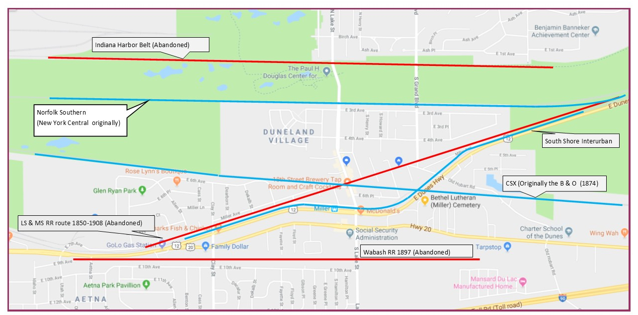
This overview map shows the abandoned and removed tracks in red, the active railroads in blue. Click on it for an enlarged view.The lines are truncated at the east and west ends.
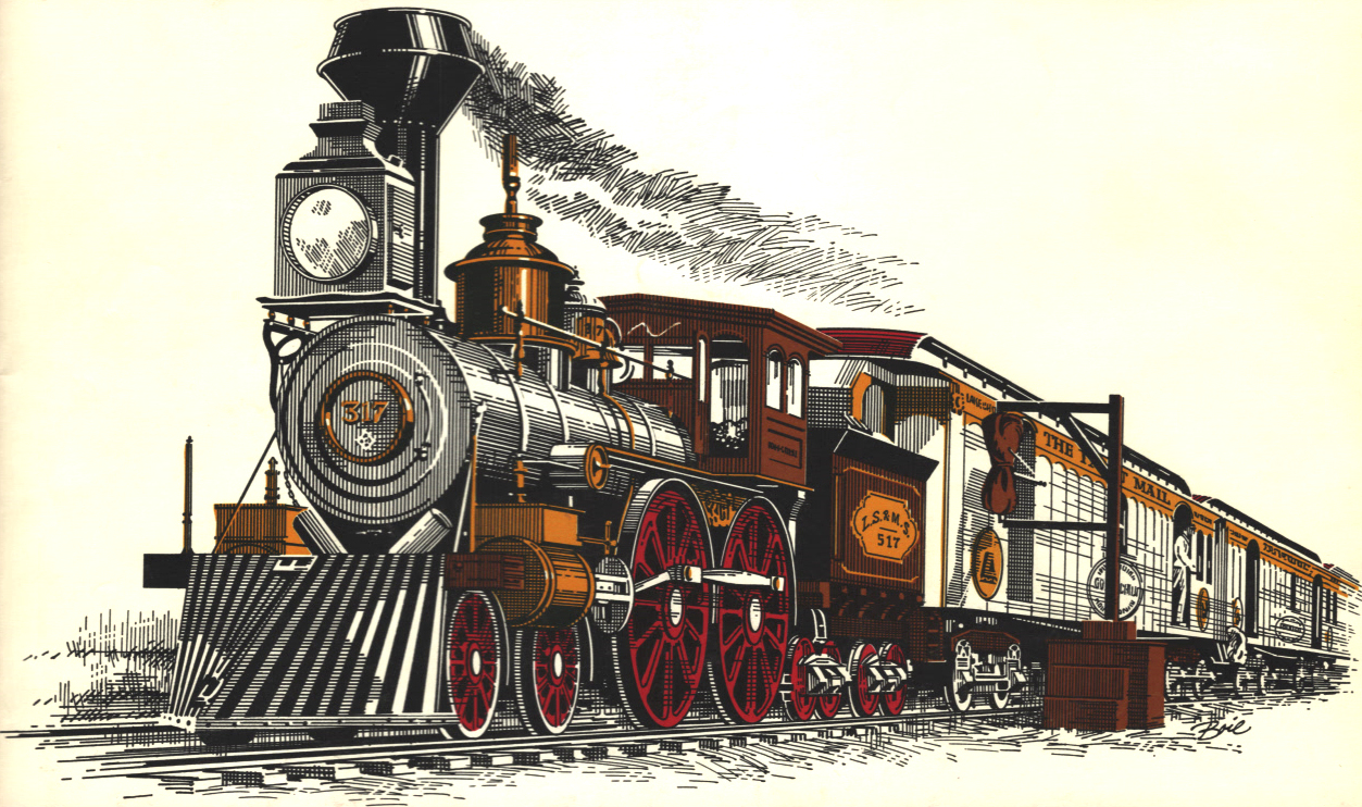
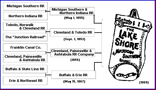
This illustration by Chuck Boie is on the dust jacket of Dave McLellan and Bill Warrick's excellent book The Lake Shore & Michigan Southern Railway.


Click on the logo to go to the section.


"From 1869 to 1914, the Lake Shore & Michigan Southern Railway was the route of empire as the young American nation began its expansion westward. It's tracks, laid by several of its predecessor lines, were the first rail connection between New York City and Chicago. Thereafter, the rail line became the crucial link and backbone of the burgeoning industrial and agricultural heartland...For generations after the Civil War, the L.S & M.S. was the best way West." (Footnote: McLellan, David, and Bill Warrick. 1989. The Lake Shore & Michigan Southern Railway. Polo, Ill: Transportation Trails. Page 9. )
The granddaddy of the railroads in Miller beach was of the Lake Shore and Michigan Southern which won a race with the Michigan Central to be the first railroad from the east to reach Chicago. The LS&MS was an amalgamation of smaller railroads consolidated in 1869 The first tracks through the difficult sandy and swampy land at the south end of Lake Michigan were actually laid by the Northern Indiana Railroad and its sister railroad, the Michigan Southern, both under the control of the Litchfield brothers, Edwin and Elisha. The first passenger train from Toledo to Chicago arrived in that city on May 22 of 1852. Those two railroads consolidated under the name of the Lake Shore and Northern Indiana Railroad in 1855. The final amalgamation into the LS&MS occurred in 1869 when a financial panic lowered stock prices to where Commodore Vanderbilt was able to purchase controlling interest, giving him the line from New York to Chicago that he wanted. The LS&MS, commonly called the "Lake Shore", continued under that name until 1914 when it finally became part of the New York Central in name. (Footnote: Ibid, McLellan and Warrick. )
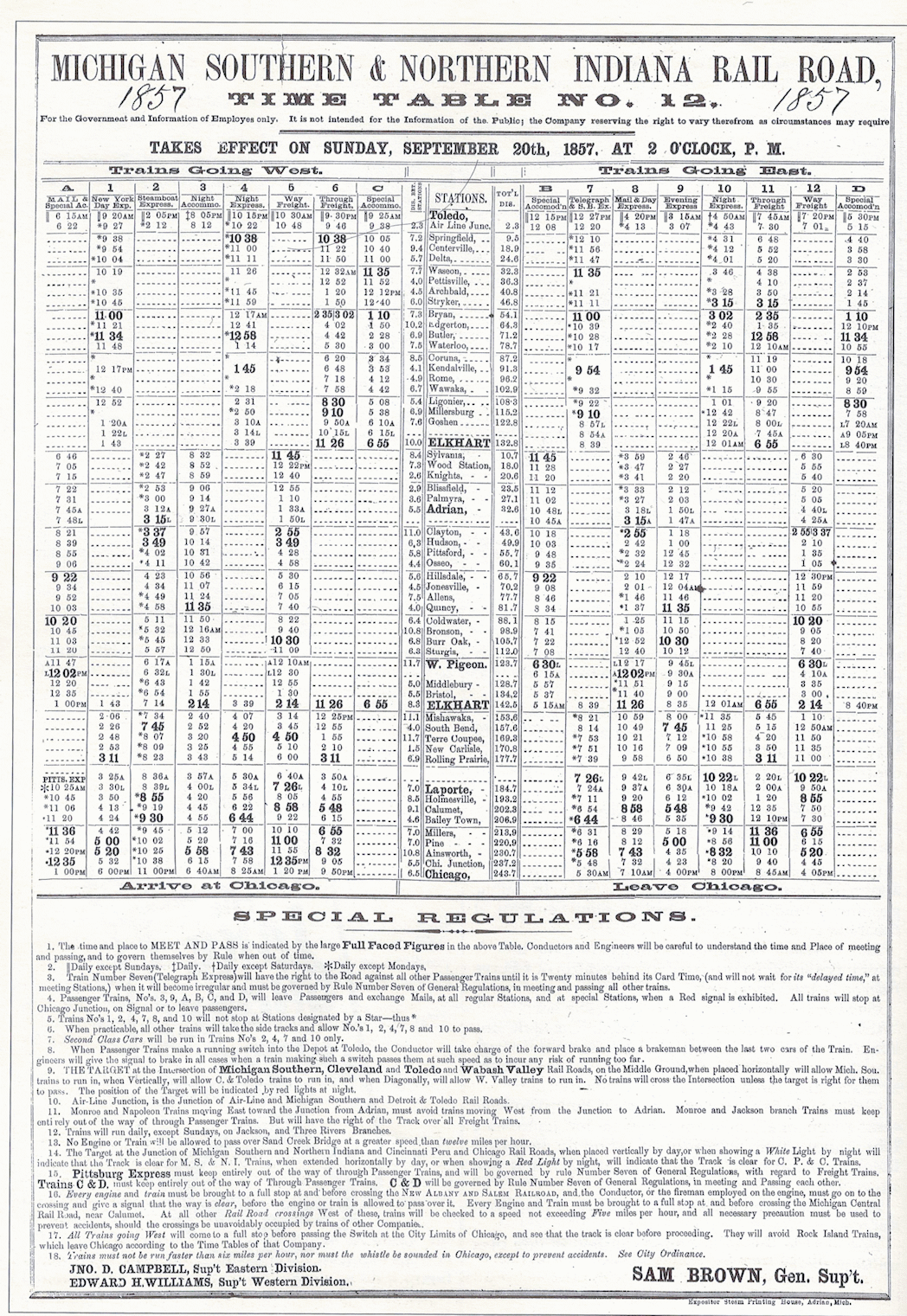
The 1857 timetable of the LS&MS shows 5 regular stops in Miller westbound from Elkhart to Chicago and 4 stops eastbound. (Footnote:
Ibid, McLellan and Warrick, page 24.
)
Click to enlarge.
The Tracks in Miller
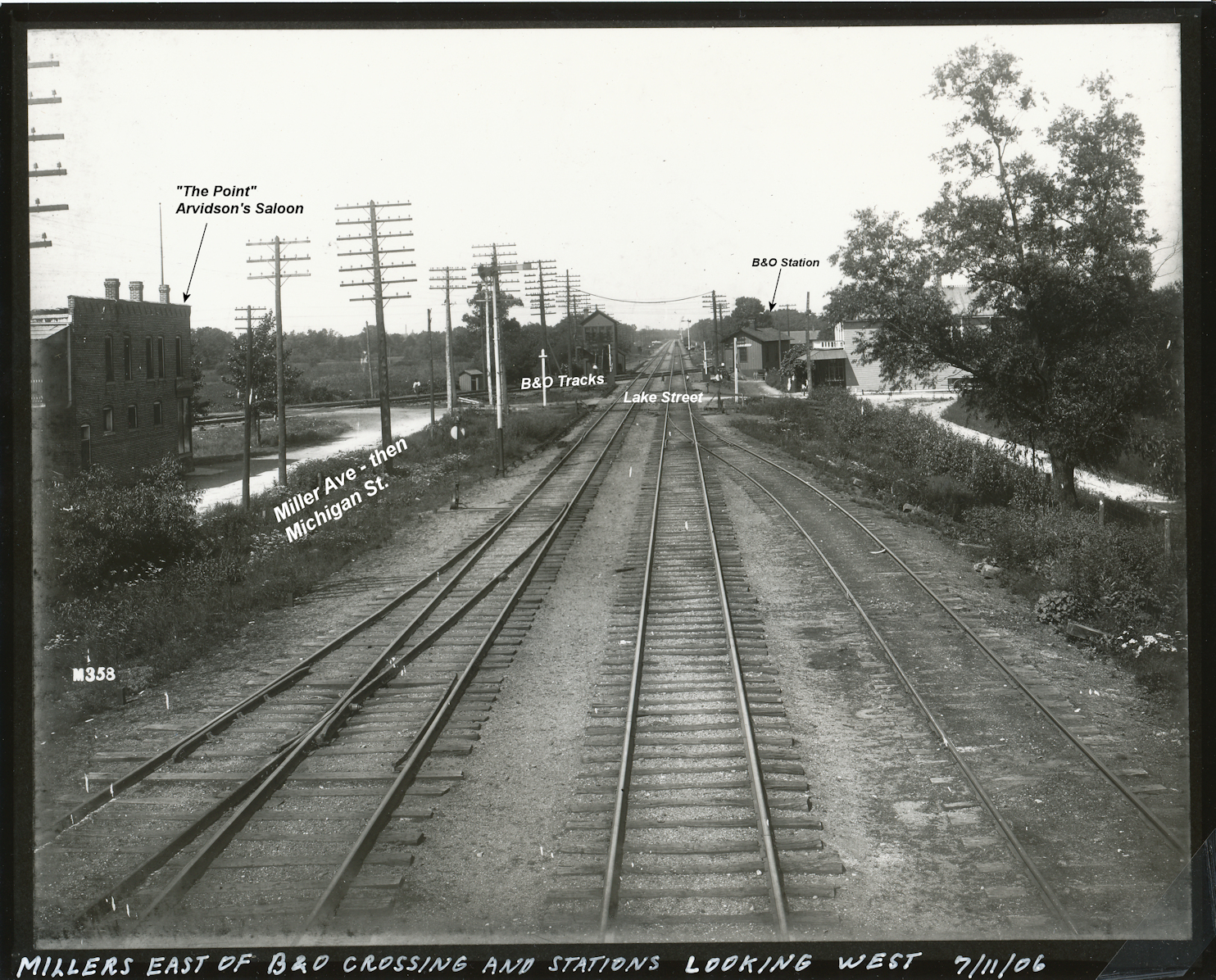
These two photos, taken in 1906, are the tracks down Miller Ave in 1906, the year before they were torn out and moved north. The photo on the left is looking east from west of the Lake Street crossing with the B&O. The photo on the right is looking west from just east of the crossing. In it you can see the "Point" bar which still stands. The annotated photo is a closer view.
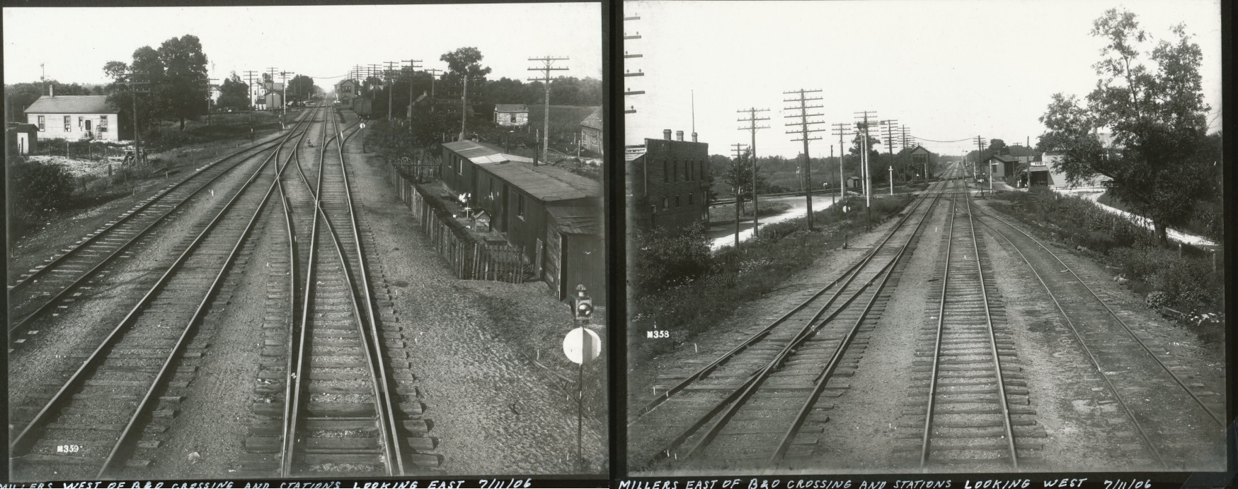
Confused about what you are looking at here? This map on another page should help.
Enlarge this annotated view looking west to see familiar landmarks.
In 1902 the first run of one of America's most celebrated trains, the 20th Century Limited, sped down these tracks for the first time at close to 60 miles an hour.
In 1907 the tracks down what is now Miller Ave. were torn up and the line moved north to just north of today's 3rd Ave where they are today, owned by the Norfolk Southern. (Footnote: Lake Shore and Michigan Southern Railway Company. n.d. Annual report. [1907]. Cleveland, Ohio page 11 shows an expenditure of $34,560.74 for a "Change of line" from Millers to Indiana Harbor. Annual reports for the LS&MS from 1870 to 1914 are online at the Canada Southern Railway website. Also at The Transportation History Collection:Railroads of the University of Michigan. )
The removal of the tracks in 1907 was not without controversy, or incident. The railroad condemned about 43 acres of land to relocate the tracks, offering the
Lake Shore Sand company not as much money as it felt was due. The sand company took them to court and was awarded a verdict of $73,000. (Footnote:
“Famous Lawsuit is Ended,” The Times, May 18, 1908
)
 While the railroad built a freight and passenger station on Lake Street just north of 3rd street, a
fire in its yard in Elkhart in January of 1908 gave the railroad the idea of re-establishing the yard in Miller. It was reported that they bought 376 acres to
build a mammoth yard in Miller. (Footnote:
"Town of Miller to Boom," The Weekly Republican (Plymouth, IN), January 30, 1908, page 8. Likely never more than a rumor.
) There was even talk of closing Lake Street. When the town voted in 1910 to improve Lake Street with sidewalks,
the railroad filed a remonstrance to prevent the sidewalk across it’s right-of-way. (Footnote:
"Will Carry Matter Into Higher Courts," The Times, December 22, 1910, page 8
)
While the railroad built a freight and passenger station on Lake Street just north of 3rd street, a
fire in its yard in Elkhart in January of 1908 gave the railroad the idea of re-establishing the yard in Miller. It was reported that they bought 376 acres to
build a mammoth yard in Miller. (Footnote:
"Town of Miller to Boom," The Weekly Republican (Plymouth, IN), January 30, 1908, page 8. Likely never more than a rumor.
) There was even talk of closing Lake Street. When the town voted in 1910 to improve Lake Street with sidewalks,
the railroad filed a remonstrance to prevent the sidewalk across it’s right-of-way. (Footnote:
"Will Carry Matter Into Higher Courts," The Times, December 22, 1910, page 8
)
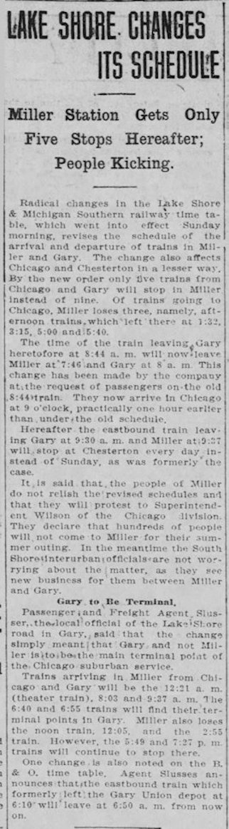
Things were not going well between the railroad and the people of Miller. A year earlier the railroad had reduced its number of stops
from nine to five, and the folks were upset. (Footnote:
“Miller Station Gets only Five Stops Hereafter; People Kicking,” The Times, June 1, 1909
 )
While the NYC station was closer to the beach, competition in ridership from Chicago
had kicked in with the start of the Chicago South Shore and South Bend Railroad in 1908, and the B&O passenger station was also competition.
)
While the NYC station was closer to the beach, competition in ridership from Chicago
had kicked in with the start of the Chicago South Shore and South Bend Railroad in 1908, and the B&O passenger station was also competition.
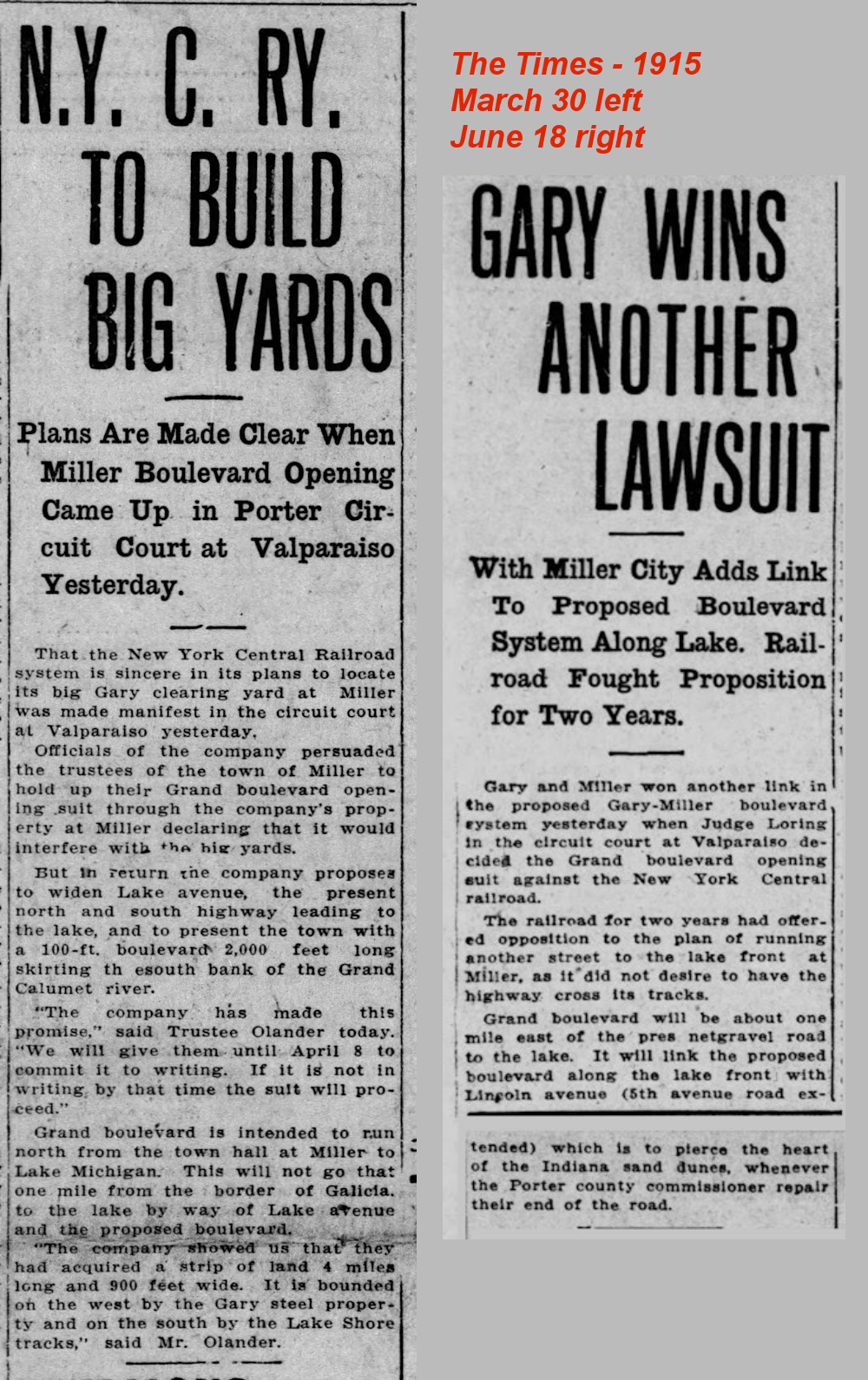 The railroad’s desire to have a big yard in Miller didn’t end in 1910.
In 1915 it tried to stop the
opening of Grand Boulevard because it would interfere with their proposed yard. They even offered to pave Lake Street and build a new road to the beach,
but when they failed to put that in writing the town trustees went to court which ordered the town to go ahead with opening Grand Boulevard.
The railroad’s desire to have a big yard in Miller didn’t end in 1910.
In 1915 it tried to stop the
opening of Grand Boulevard because it would interfere with their proposed yard. They even offered to pave Lake Street and build a new road to the beach,
but when they failed to put that in writing the town trustees went to court which ordered the town to go ahead with opening Grand Boulevard.
We probably have the Miller trustees and folks back in the 1910s to thank that quirky, beach-going Miller isn’t one big railroad yard today.
The station at Lake and 3rd remained until the mid-1950s, but Lake Shore timetables of 1911 and 1914 show only two stops, both westbound. Successive timetables that I’ve found show no stops at all. See this page for timetables of the NYC, LS&MS, Michigan Central.
In 1918 the map of the New York Central Lines, comprised of 12 separate lines, claimed to operate 13,000 miles of railway in territory containing more than one-half the population of the United States. The New York Central continued to operate as such until its merger with the Penn Central in 1968.
The Indiana Harbor Belt
Newcomers, and even long-time residents, may wonder from time to time why an unusable footbridge spans Grand Boulevard. The bridge is fenced off on both ends. A number of years ago the National Park system built the bridge which could connect Marquette trail on the east to a path leading westward towards Lake Street and Miller Woods. Unfortunately, a similar bridge over Lake Street was never built and the path can’t be used between the east side of Grand Boulevard and Miller Woods. The old right-of-way west of Grand Boulevard to Miller Woods is owned variously by CXS, the Park Department, the E.J.&E Railroad, and a private individual. An aerial map shows the path.
The origin of the Harbor Belt tracks in Miller is best described by this quote from the online Indiana Harbor Belt Archive History:
“A final piece of the Harbor puzzle was the another NYC venture known as the Gary & Western, built around the time U.S. Steel's enormous Gary Works was constructed. It extended east from Ivanhoe (ed. SE corner of U.S. 12 and Cline Ave.) on the west side of Gary, Indiana, running through the central part of the city on an elevation. On Gary's east side it turned north toward the steel mill and then headed east again near the lakefront. Here, it connected to a segment of a Chicago, Indiana & Southern line that ran to what is now Burns Harbor, Indiana. Both the G&W and the CI&S route were owned by New York Central, but the Harbor operated them. They served several industries in Gary, and also hauled sand and other bulk commodities from the Burns Harbor area. When CI&S was folded into the New York Central System in 1914, the Harbor leased the G&W/CI&S route from the Central.”
The IHB still functions over the Norfolk Southern's ex-New York Central tracks. When the old right-of-way in Miller was removed is not clear, but likely in the 1980s when Miller Woods, Marquette Trail, and the Paul H. Douglas Center for Environmental Education were established by the National Park system. The Douglas Center was opened in the fall of 1986.
The Wabash Railroad
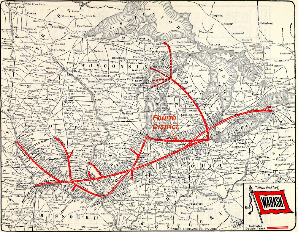
While not strictly part of Miller, Aetna shares the same zip code and has had a close relationship. It has a history that goes back to 1881 and was a separate town for many years before being annexed by Gary in 1927. The Wabash Railroad, skirting along the south edge of Miller, carried freight and passengers to the Aetna Powder Company until it folded in 1919. Tracks came through about 1893 when the Wabash built its Fourth District line from Detroit to Chicago. Until then the dynamite from the Powder Company had to be trundled over on make-shift tracks to the depot of the LS&MS in Miller. There is more about this on the Aetna Powder works maps and photos page.
.jpg)
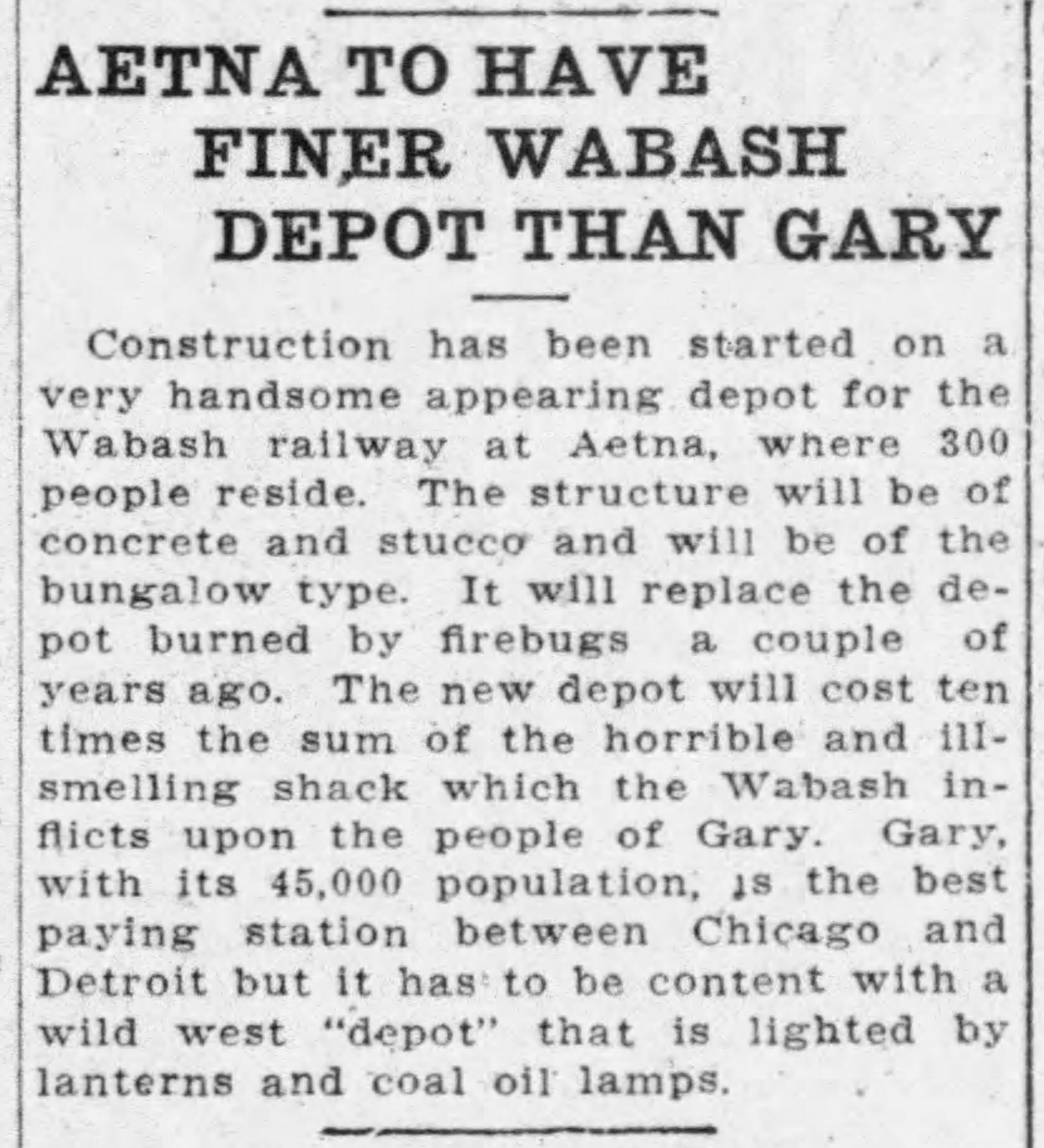
There are very few remnants of the Wabash on the east side of Lake County, but one significant one is the depot in Aetna, only one of six remaining depots of the Fourth District. (Footnote: Email from Victor A. Baird, author of Railroading on the Wabash Fourth District. ) Built in 1914 to replace the original that burned in 1912, (Footnote: "Aetna To Have Finer Wabash Depot Than Gary," The Times, June 4, 1914. ) it was moved across Aetna street and for years was used as a real estate office. Again, there is more about both depots on the Powder Works maps page.
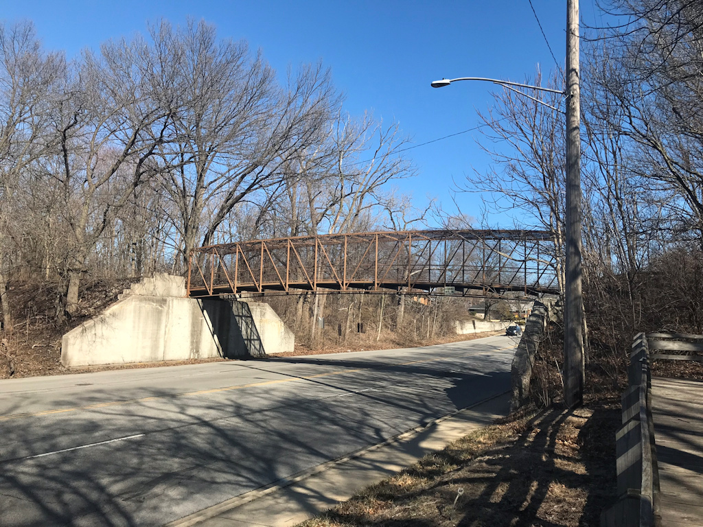
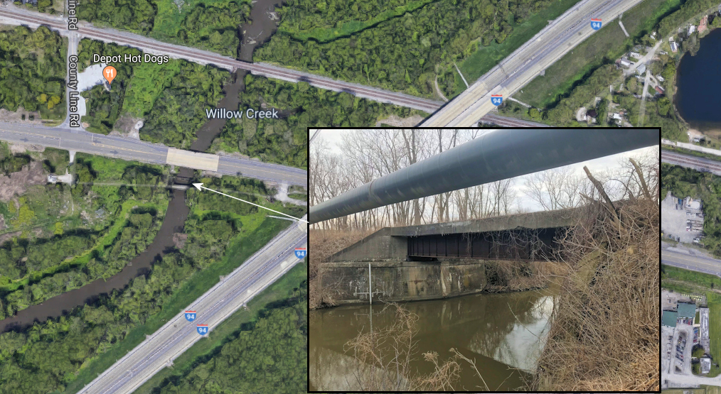
Another remnant not strictly in Miller, or Lake County, is just over the county line road in Porter county. Across U.S. 20 from the Depot Dog and hidden from a good view by a pipeline is an old bridge of the Wabash spanning Burns Ditch. The raised roadbed is visible leading to the bridge from the east paralleling U.S. 20.
The Baltimore & Ohio and CSX
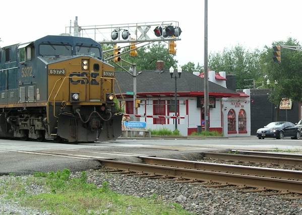
In 1910 the B&O built a new depot in Miller to replace the depot it had shared with the LS&MS for close to forty years. (Footnote:
“Miller is Having a Boom,” Times, Dec 9, 1910, page 5. – “But best of all and the pride of Miller is its new union depot being built in the “loop” district by that hoary institution,
the Baltimore & Ohio railroad, which in the days of yore only permitted the milk train to stop at the little town.”
)
The old depot had burned down the year before in a total loss that
saw the citizens of the town save surrounding buildings, including the post office, which was saved by throwing snowballs
on the roof as the article describes.

The B&O, which had built tracks through Miller in 1874, would see passenger service until World War Two. Both a 1928 and 1933 timetable of the B&O show two stops of a “milk train” stopping in Miller on its way towards Chicago originating from Garrett, Indiana. While timetables are hard to come by online, the depot continued as a freight station until 1957 but the Miller passenger station disappears as of the 1941 city directory. After 1957 the depot was used as a tool shed, then bought and moved 40 feet north in 1991 to become the Miller Pizza Company’s dining room.(Footnote: "Miller Pizza Station worth a stop," The Times, June 17, 1994, page 59 quoting Scott Goldberg, the owner. Also City Directory entries in the street guides for 622 S. Lake Street. )
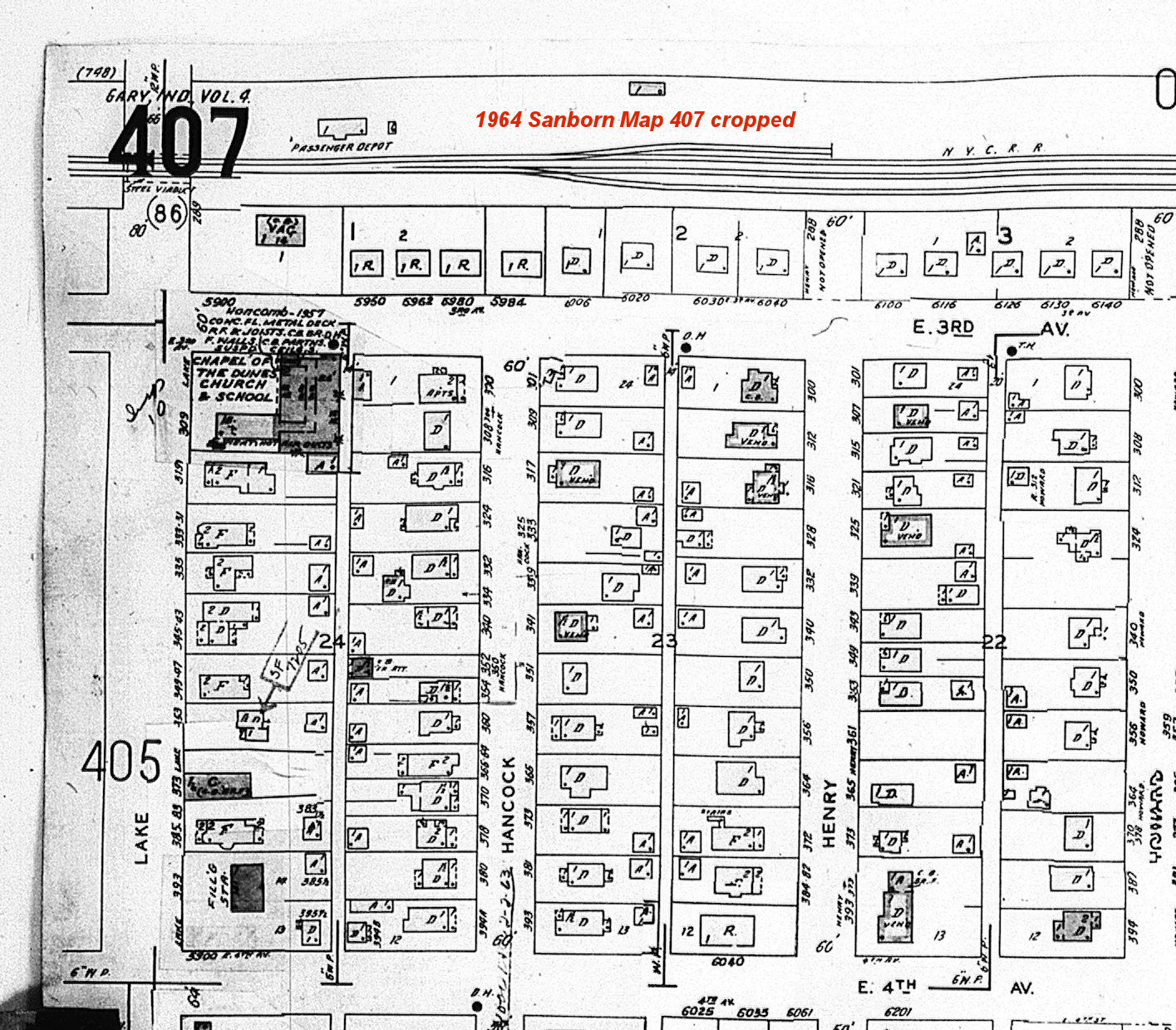
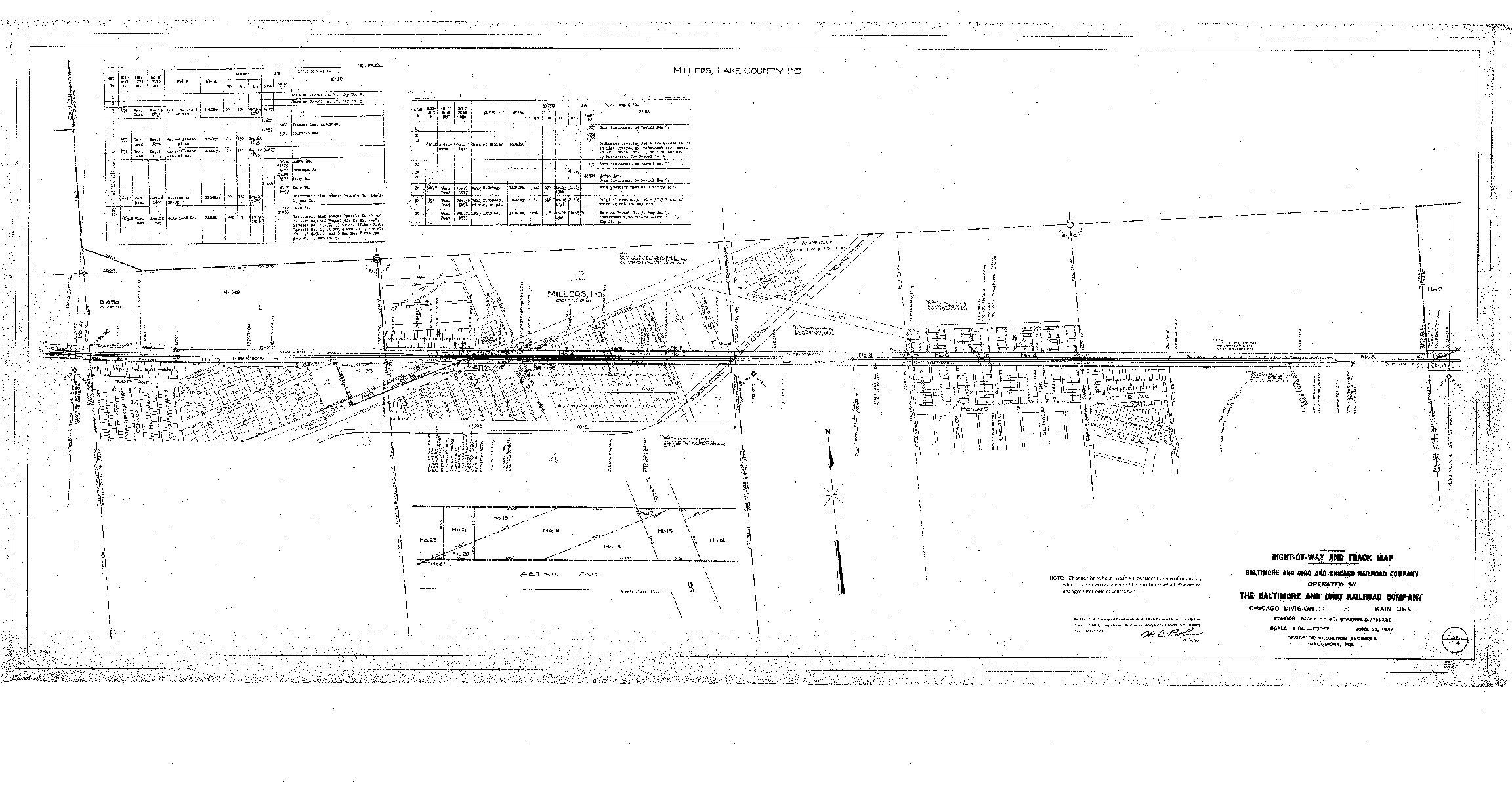
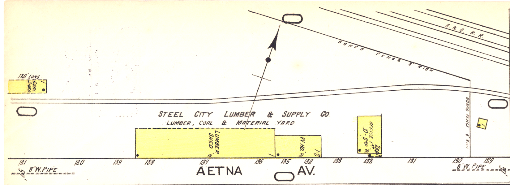
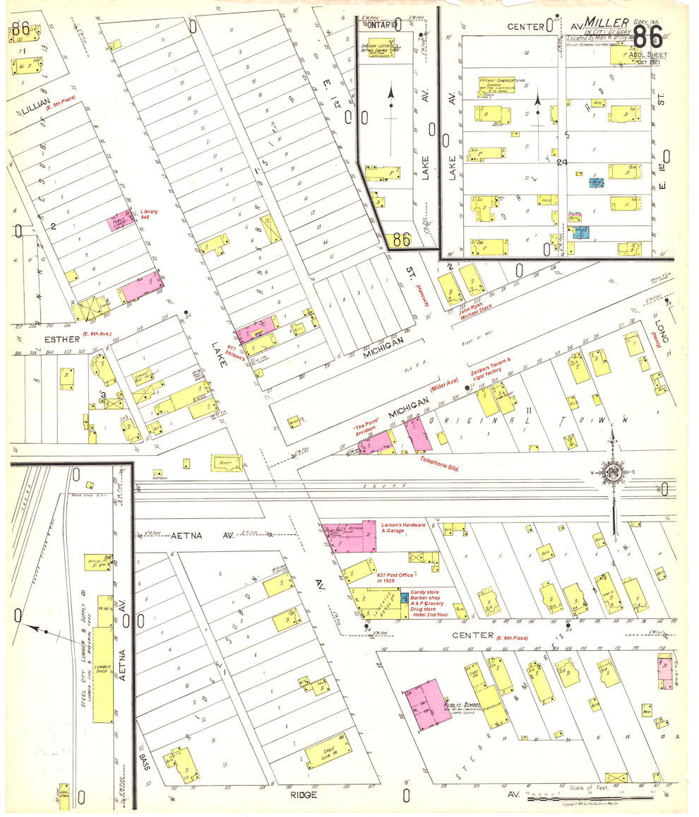
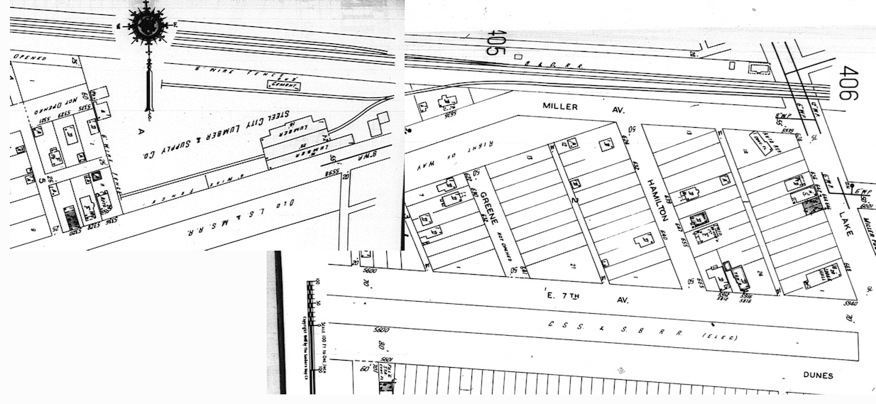
The B&O’s primary customer in Miller was Steel City Lumber, later Broadway Lumber and now Kidstuff Playsystems. The 1918 valuation track map shows not only the depot, but a house for the railroad’s section foreman and a siding for coal. Steel City Lumber incorporated in 1921 with a capital of fifty thousand dollars and appeared in an inset on the 1921 Sanborn Fire Insurance map.
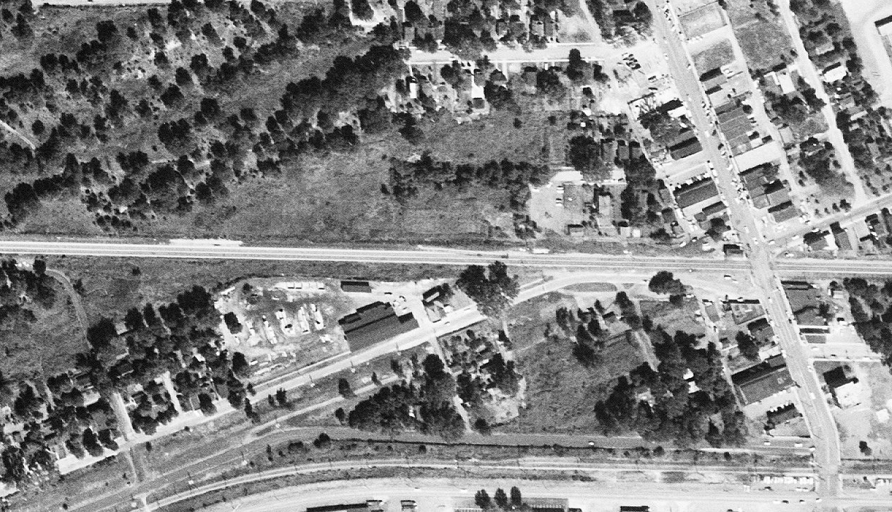
The following maps and photo show the development of the B&O's primary customer from
1918 to 1964 using track maps and
Sanborn Fire Insurance Company maps.
1918 Baltimore and Ohio Track map cropped

Full size track map opens in a PDF:
1921 Sanborn map inset:
Full 1921 Sanborn map annotated some.
1945 Steel City Lumber Sanborn map stitched from two maps:
A 1952 Aerial photo of the same area.
1964 Broadway Lumber Sanborn map.
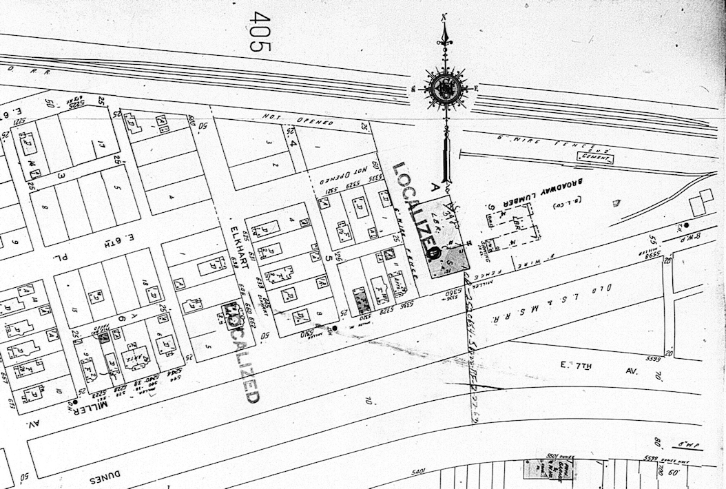
Notice in both 1945 and 1964 the "Cement" shed which still stands in 2019. All show either an "Office" and/or a house that was used by the section foreman.
Also notice the street names in 1918 and 1921 which hadn't been changed yet.
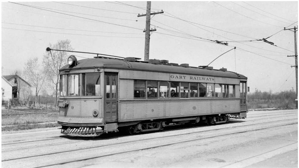
Gary Railways street car.
In April of 1924 the 5th avenue line to the newly built National Tube plant the Gary Street Railway was extended down 7th avenue to Lake Street in Miller in November of the same year. It would operate that line for 11 years until it was discontinued in 1935, replaced by busses. (Footnote: Buckley, James J. Gary Railways. Chicago: Central Electric Railfans' Association, 1975. Print., Pages 7 and 19. ) I’m told old-timers in Miller remember taking the street car to Emerson school. (Footnote: Via Catherine Shough Facebook comment: "An older lady who lived on Hancock says she would ride the Street Car to Emerson." )
With the building of Marquette Park the railway had great plans for extending its line into Miller and on to the county line. The automobile won out but the railway filed a legal notice in the Times that it would be extending the line down Grand Boulevard to Hickory, then along Montgomery to Maple and then eastward to the eastern limits of Gary. (Footnote: “Notice,” Section II, Hammond Times, April 26, 1924, page 12. )
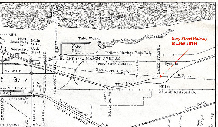
Cropped section of the Gary Railways cumulative map.
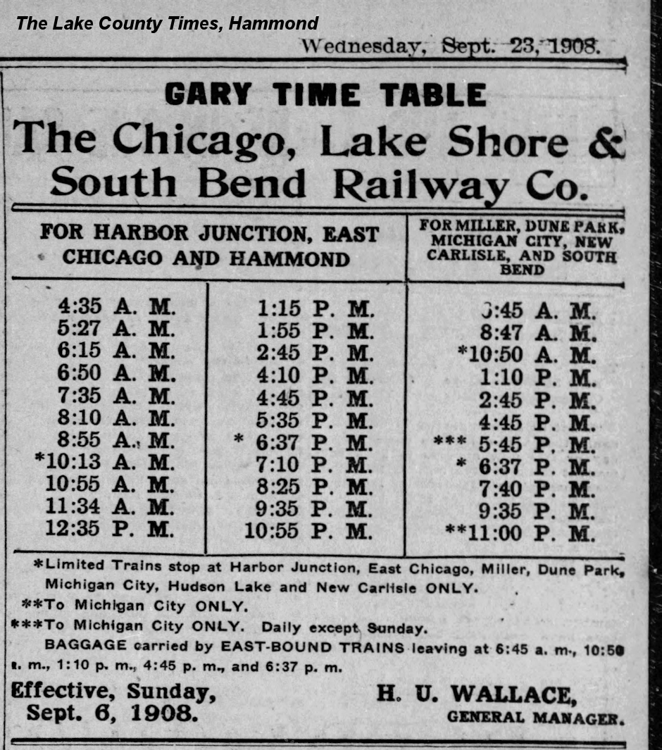
Much has been written about the South Shore Line, now known as NICTD, the Northern Indiana Commuter Transportation District. Suffice it to say here that the line has stopped in Miller from when the line was completed to South Bend in September of 1908 as the Gary timetable ad in The Times indicates.
In November of 1908 officials of the railway nicknamed it the “South Shore Route,” but over the years it has been known simply as the “South Shore.” (Footnote: “Name New Interurban ‘South Shore Route’”, South Bend Tribune, Nov 30, 1908 page 1. ) The same newspaper article notes that the trip from South Bend to Chicago’s LaSalle street station would take you two hours and 45 minutes, not a whole lot different than today’s trip depending on stops your train makes.
"Riding the Rails of History" teaser:
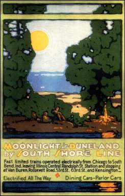
The long history of the line which brought beach-goers to Miller and is used by commuters is well documented in Paul Nelson’s documentary “Riding the Rails of History” which can be watched at Vimeo or purchased by contacting Lakeshore Public Media. The wonderful posters that have been created were collected in Ronald Cohen and Steve McShane’s beautiful book, Moonlight in Duneland.
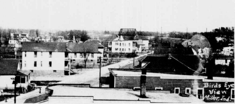
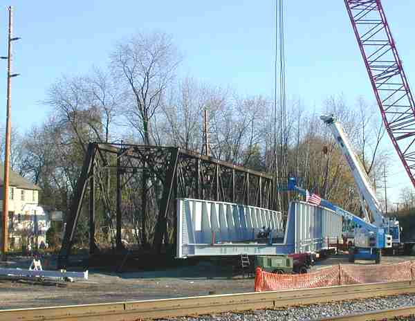
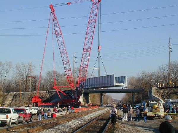
On November 9th and 10th, 2001, the 95 year old, iconic South Shore bridge over Old Hobart Road in Miller was replaced. The "birdseye" view down E. Sixth Place sometime in the 1920s from the roof of Miller school shows the bridge in the distance.
"Birds Eye." Mouse over for a magnifier. Use the wheel on your mouse too.
November, 2001:
Credits, Acknowledgements, and Resouces
- Original photos of the tracks in Miller are in my possession thanks to Bill Warrick and David McLellan who sent them
to me in the 1990s when I first did a webpage on the railway and the tracks that used to run in front of my house. Their book
The Lake Shore & Michigan Southern Railway is an invaluable resource on the history of that railroad.
McLellan, David, and Bill Warrick. 1989. The Lake Shore & Michigan Southern Railway. Polo, Ill: Transportation Trails.
While out-of-print, it is available at a number of libraries. - Baird, Victor A. Railroading on the Wabash Fourth District., 2013. Print. - Victor Baird's excellent book on the Wabash's line from Detroit to Chicago. Find it at a library near you or order a copy on Ebay from the publisher and author.
- The 1918 valuation track map was purchased by me in 2015 from The B&O Railroad Museum Thanks to Ryan McPherson, the archivist.
- Sanborn Fire Insurance Maps are from microfilm at the Lake County Library.
- Buckley, James J. Gary Railways. Chicago: Central Electric Railfans' Association, 1975. Print.
- Gary Railways car: W.H. Bass Photo Company Collection, Indiana Historical Society. Indiana Historical Society image. The Shore Line Interurban Historical Society for Gary Railway logo and more information on the Railway.