Native Americans
and the
Potawatomi in Miller
A great number of individual Potawatomi were granted reserves in some sixty treaties between 1789 and 1867, 259 reservations in Indiana and Illinois between 1818 and 1832. This page explores the region as it was in 1830 and the treaty of October 27, 1832 which granted land in Miller to four Potawatomi individuals or bands.
When Father Marquette, for whom Miller’s Marquette Park is named, camped at the mouth of the Grand Calumet in 1675, the Native Americans in the area were Miami Indians, likely of the Wea Tribe. Most Millerites are familiar with Father Marquette’s visit, but for a summary, see the page on this website on Marquette Park. In the succeeding decades, after bitter fighting with the Illinois Indians, the Miami and Potawatomi parted company. (Footnote: Parted company: For an account of this period in Wea history see http://www.weaindiantribe.com/History.html )
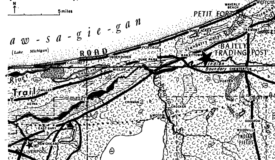
By the start of the 19th century the land around southern Lake Michigan was occupied by the Potawatomi. The land we know in Miller was largely marsh, mined by Indians for cranberries, wild rice, and certainly an abundance of wild fowl that sustained those that ventured into the marshes to harvest and hunt. Indeed, in the map created by Valparaiso University geographer and historian Alfred H. Meyer in 1954, the area we know as Miller is shaded largely as “swamp.” The two pictures provided here should provide a good idea of what the area was like. (Footnote: Meyer, Alfred H. “Circulation and Settlement Patterns of the Calumet Region of Northwest Indiana and Northeast Illinois (The First Stage of Occupance--the Pottawatomie and the Fur Trader,--1830).” Annals of the Association of American Geographers, vol. 44, no. 3, 1954, pp. 267-8. )
Crop of Prof. Meyer's 1954 map.
Note the length of Long Lake. Dense shading at the mouth of the Grand Calumet [Marquette Park] is on the map as named as "swamp" on the legend while the dimpled area indicates broadleaf trees.
Click to enlarge.

Undated with text caption from a collection of Carr Family photos.
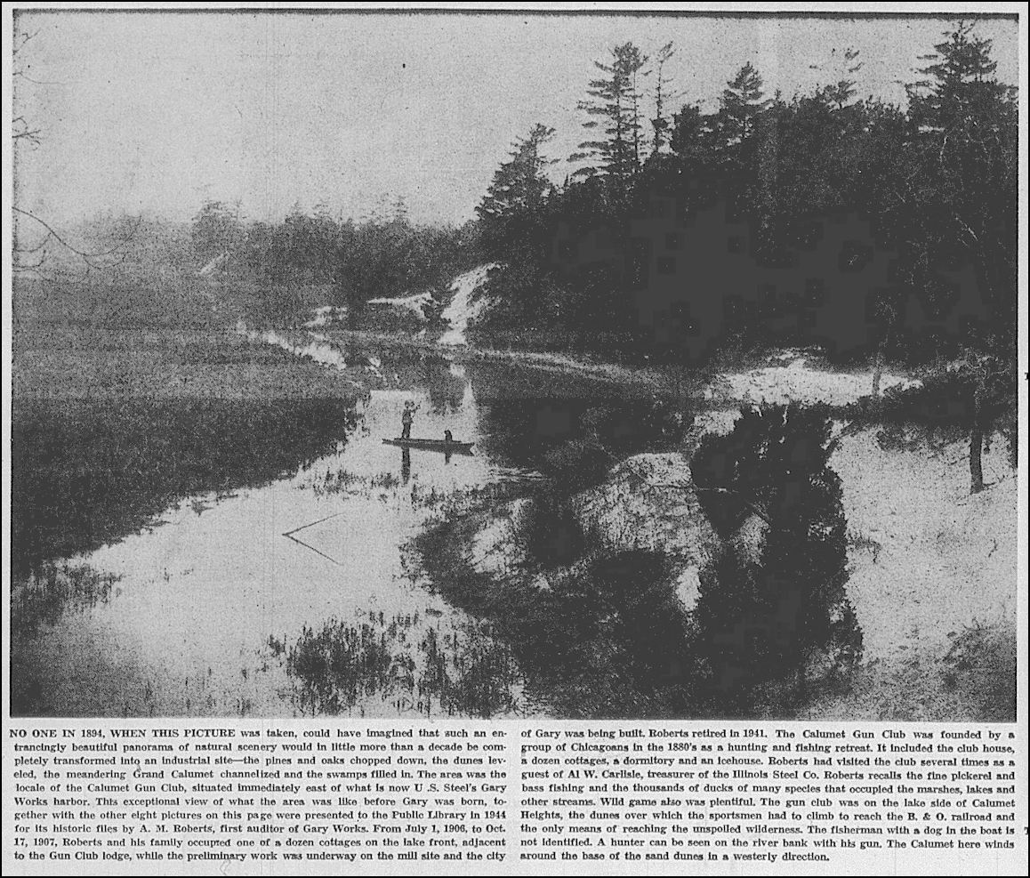
Click image to see the caption which identifies the landscape as east of the steel works, the river the Grand Calumet.
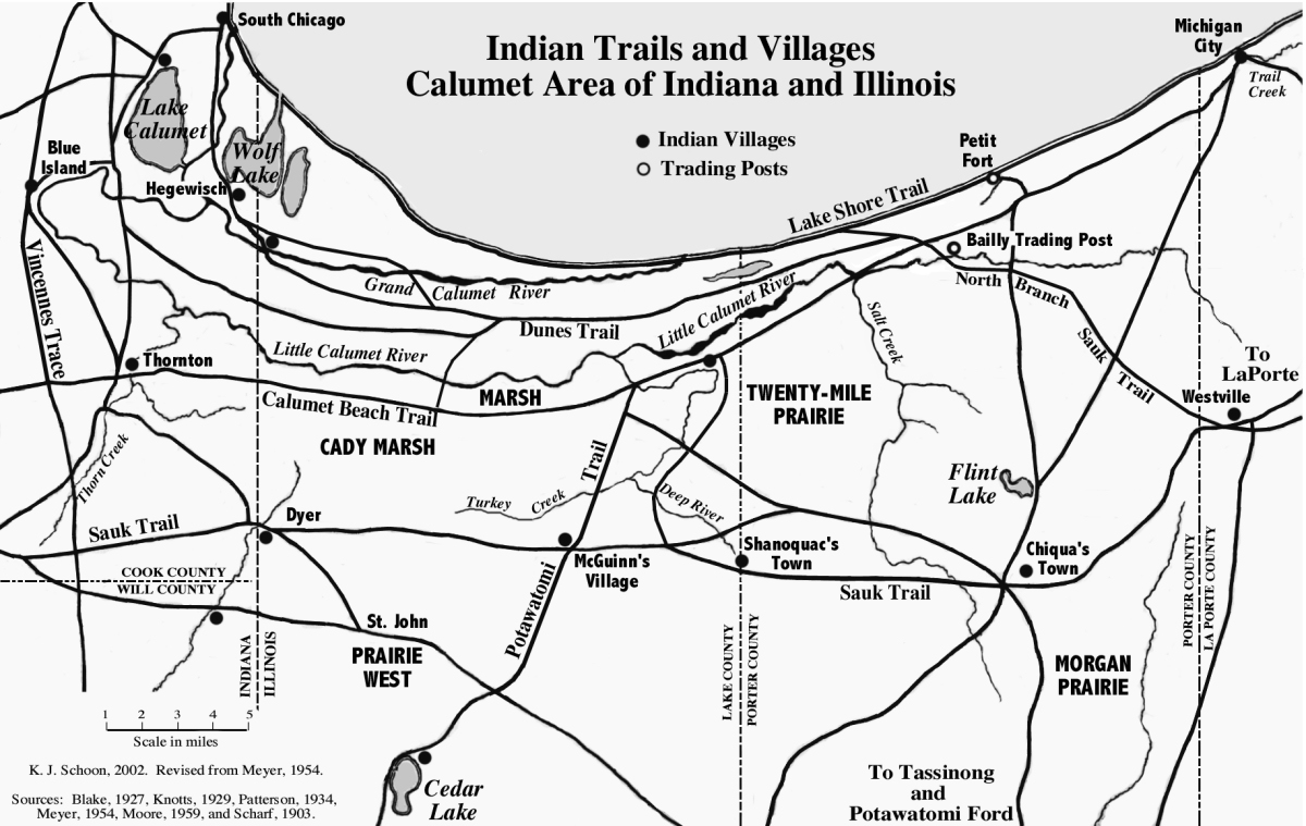
Trails, villages, trading posts ca. 1830. Image courtesy Ken Schoon.
Alfred Meyer’s 1954 research identified native trails, villages, and trading posts and has been used with some modification by Kenneth Schoon in his book, Calumet Beginnings. While the Tolleston Beach Trail, so named, traversed the Miller area, it is not surprising that villages are further south. Bailly’s Trading post, (Footnote: Bailly Homestead NPS site: Link to NPS site (New window or tab.) ) a mere 8 miles from the mouth of the Grand Calumet River [Marquette Park], was no doubt frequented by the Potawatomi who hunted, fished and gathered in this area. Indiana achieved statehood in 1816 and Lake County was formed out of Porter and Newton Counties on January 28, 1836 and became an independent political body February 16, 1837. (Footnote: Lake County origin dates: Howat William Frederick. Standard History of Lake County (Chicago, 1915), page 100. https://archive.org/details/standardhistoryo01howa/page/100/mode/2up )
Five years before that, when much of Northwest Indiana was Indian land, the Potawatomi, in three treaties at the Tippecanoe River, ceded immense tracts of land to the government.

Major Potawatomi concessions 1816-1832
From 1816 the Potawatomi had ceded land in Indiana, Michigan, Wisconsin, and Illinois. Independent researcher, Larry M. Wyckoff, in several articles, has tracked and documented these treaties in detail down to what land was reserved to what Indians.
(Footnote:
Text and maps: Wyckoff, Potawatomi Treaties with the United States, 1787-1867, page 539. See sources for full citation.
) These treaties proved useful to the invading settlers, but the Indian Removal Act of 1830 saw to forcibly remove Potawatomi in the succeeding years, including a forced removal of 859 Potawatomi from Northern Indiana to Kansas, which the Potawatomi came to call The Trail of Death.
(Footnote:
Much has been written over the years about the Indian Removals, mostly concentrating on the Cherokee and southern tribes. See the following for more on the Potawatomi removals:
1) For the Citizen Potawatomi Nation Cultural Heritage perspective see the section 1830s - 1850s at: https://www.potawatomiheritage.com/history/
2) The ubiquitous Wikipedia article: https://en.wikipedia.org/wiki/Indian_Removal_Act /
3) Potawatomi Removal Muster Rolls 1833-1840 (Wyckoff, 2017) (See Souces for link.)
)
The Treaties of October, 1832 were called at the Tippecanoe River by the treaty commissioners who wished to extinguish any remaining native title to all the Potawatomi and Miami lands in Indiana, Michigan and Illinois before removal under the 1830 Removal Act. While the Miami would not negotiate, the three treaties provided numerous reservations to the various bands and individuals in the ceded land, all named in the treaty along with the amount of land they were reserved.
The third of the three treaties, signed October 27, 1832 names four Potawatomi Indians who were granted land in general terms (e.g., Be-si-ah, four sections) in what is now Miller: Be-si-ah, Francis Page, Jr., Chieftess Miss-no-qui, and Po-ka-kause. It is in the Bureau of Land Management database that we find specific locations. 17 Potawatomi, all named in the October 27th treaty, were granted land patents from 1836 to 1871 in Lake County totaling 12.8 square miles, including the aforementioned three in Miller. For more on these 17 Potawatomi granted patents see the Appendix below.
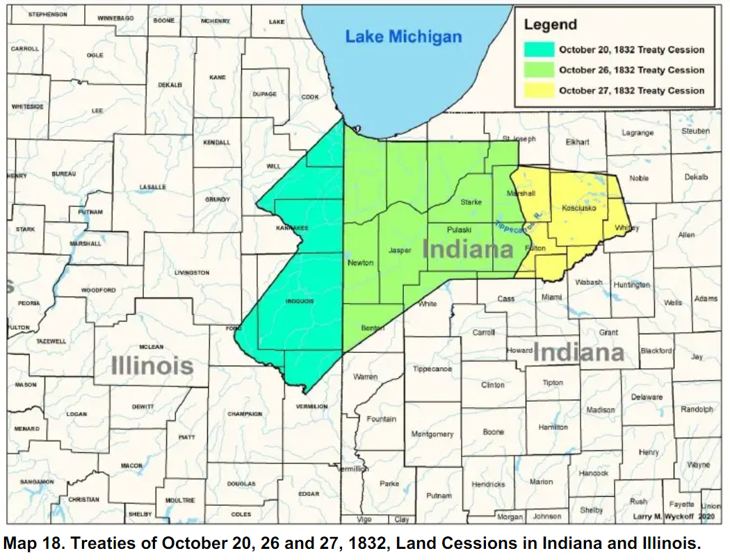
Land Cessions in October, 1832.
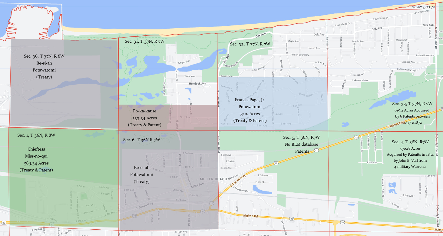
Six Sections that make up Miller. Four Potawatomi are named. The two sections east were not Potawatomi acquisitions - for information only.
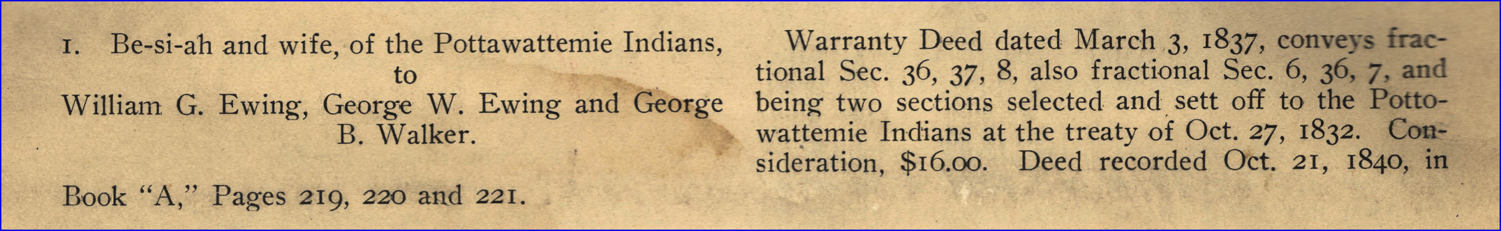
Item one in an Abstract of Title.
While Chief Be-si-ah sold his land in Miller before taking out a patent, the three others, took out patents in Miller which were, in 1887, extended by the Dawes Act. It would take rather extensive research in the Deed books, or Title Abstracts if they were found, to determine to whom and how the lands of Francis Page, Miss-no-qui and Po-ka-kause devolved, but the first entries in a title abstract for one property gives us what happened with Be-si-ah’s land.
Initially, he was granted four sections by the treaty of October 27th, but in the following months the Indian Agent, William Marshall at Logansport, was encouraged to negotiate with the treaty Indians to reduce their holdings by purchase. Be-si-ah was one among many who agreed to give up land, he selling two of his sections back for $400 in goods in a treaty signed December 20, 1834 by his mark and the mark of his wife Autch-kaw-bo-a-quay and their son Nee-paw-wee. George Washington Ewing was one of the witnesses to that 1834 treaty. The two sections Be-si-ah gave up were in Kosciusko County. In March of 1837 the House of Ewing purchased his two sections in Miller for $16.00.
Be-si-ah had little use for the two sections remaining to him, one of which, as seen in the map, would be downtown Miller, the other now largely U. S. Steel property. Having sold the that land to the Ewings in 1837, he then asked for relief from the government, which authorized him to “select and enter four sections of land in the district of lands subject to sale at Winamac or Fort Wayne, Indiana, in tracts of not less than one quarter section each…to be held and taken in lieu of the reserve of four sections granted to said Besiah [by the treaty of 1832].” (Footnote: H. R. 184 [Report No. 542, Feb. 28, 1844 & June 7, 1844, 28th Congress, 1st Session; Online at http://rs5.loc.gov/cgi-bin/ampage?collId=llhb&fileName=028/llhb028.db&recNum=495 Those sections have not been found in the BLM database ) He apparently died by 1853, as his “sister and sole heir” As-nich got $60 out of the Ewings to convey all her interest by a Quit Claim Deed dated May 1, 1853. (Footnote: As-nich: Abstract of Title, page 1, Item 3. ) The “House of Ewing” was falling apart by then; William G. Ewing, the elder brother and senior partner, died in the summer of 1854. I suspect the land they owned in Miller reverted back to the United States given the trouble they had been in with irregularities in monies they were to have conveyed to the Potawatomi. Item 5 in the Title Abstract is for a patent from the United States to one Joseph M. Trowbridge for 220.79 acres in 1857 - the north half of section 6. (Footnote: House of Ewing: see Trennert, Epilogue and Conclusion, p. 202 ff.; Conveyance of land in Section 6: BLM Accession IN3150__.374 – cash sale to Joseph M. Trowbridge. Abstract of Title, Item 5. (North ½ Section 6 of 220.79 acres) )
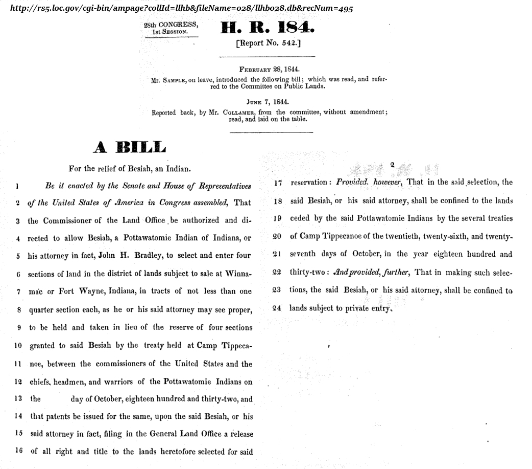
28thCongress, 1st Session, H. R. 184, Report 542 - A Bill for the relief of Besiah, an Indian.
The following spreadsheet shows all the 17 Potawatomi patents in Lake County between 1836 and 1871.
Clicking on the Accession number (second column) will open the Bureau of Land Management record in a new window. Rows in green are those three in Miller.
For the source of this spreadsheet see the sources below: Bureau of Land Management entry.
Powell Moore makes reference to only one individual Potawatomi Indian, Ben-Ack, noting that his was the first deed recorded in Lake County from “a patent from the United States government.” Click on Ben-Ack’s accession number below for the full record in a new window and in the tabs there choose “Patent Image” see the original certificate. His land patented was 640 acres of what is now downtown Hobart. (Footnote: Ben-Ack: Moore, The Calumet Region, page 70-71, fns 89 & 91. )
Most folks are not all that familiar with the Public Land Survey System, the surveying method developed in 1785 that divided real property for sale and settling. Essentially it consists of Townships (not to be confused with political Townships) 36 square miles divided into 36 Sections of one mile square. Townships are located east or west from a Principal Meridian and north from a BaseLine. For Indiana the BaseLine was in the southern part of the state. The Principal Meridian, the Second, is a N-S Longitudinal line at 86°27'21"W. The map at the top of the Wikipedia article helps explain BaseLines and Meridians, and perhaps the diagram will also help with Township Sections. An Aliquot is a described portion of a section.
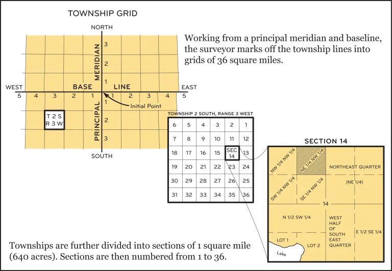
Township Grid diagram
This page was inspired by two major sources, an Abstract of Title in Gene Ayer’s office and the incredible work of Larry M. Wyckoff, an independent researcher who has published a number of articles on Native American history at academia.edu. Three articles of particular interest for the Potawatomi of Northwest Indiana are the first two.
All links open in a new window or tab.
- Wycokoff, Larry M.
- Wyckoff: "Potawatomi Reservations in Indiana and Illinois, 1818-1832" (2020) A listing and maps showing the locations of the 259 reservations granted to the Potawatomi in Indiana and Illinois by their treaties with the United States. 95 pages. https://www.academia.edu/42135555/Potawatomi_Reservations_in_Indiana_and_Illinois_1818_1832
- Wyckoff: "Potawatomi Treaties with the United States, 1787-1867" (2021).With over sixty treaties, the Potawatomi Indians participated in more treaties with the United States than any other Indian Tribe. Not all of these treaties were ratified. This report pulls together various documents relating to each treaty including a copy of the treaty. With maps showing the lands ceded. (886 pages.) This is probably the best description of the three treaties in late October, 1832. See page 553-ff for the treaty of October 27th. https://www.academia.edu/49454204/Potawatomi_Treaties_with_the_United_States_1789_1867
- Wyckoff: "Potawatomi Removal Muster Rolls 1833-1840" (2017). Muster rolls of Potawatomi Indians who were removed from Wisconsin, Illinois, Indiana and Michigan to lands west of the Mississippi in the years 1833 to 1840. Not used in my research, but worth inclusion here. https://www.academia.edu/34674002/Potawatomi_Removal_Muster_Rolls_1833_1840
- Abstract of Title: in the possession of Gene Ayers, Gary, Indiana. This Abstract is for one lot on South Howard Street in the northern half of Section 6. It traces the ownership back to the initial owner, Besiah. The first page is the one relevant for this study. First item used in the text, but for the whole first page click here. The Abstract, stored for many years curled up, is a difficult scan.
- Bureau of Land Management, Database online: https://glorecords.blm.gov/search/default.aspx The spreadsheet used in the text is from using this database searching Location: Indiana > Lake, and Miscellaneous: Tribe > Potawatomie (sic). The results exported to a spreadsheet copied into Google Sheets for publishing ability. See the results directly by clicking here
- Schoon Kenneth J. Calumet Beginnings: Ancient Shorelines and Settlements at the South End of Lake Michigan. Indiana University Press 2003.
- Moore Powell A. The Calumet Region: Indiana's Last Frontier. Indiana Historical Bureau 1977 1959.
- Meyer, Alfred H. Both articles retrieved from Jstor.org by a nice IUN librarian. Very clear copys.
- Meyer, Alfred H. “Circulation and Settlement Patterns of the Calumet Region of Northwest Indiana and Northeast Illinois (The First Stage of Occupance--the Pottawatomie and the Fur Trader,--1830).” Annals of the Association of American Geographers, vol. 44, no. 3, 1954, pp. 245–74. Available online at https://archive.org/details/CirculationAndSettlement1830/page/n1/mode/2up - Scanned reprint at the Lake County Library and a fairly muddy copy.
- Meyer, Alfred H. “Circulation and Settlement Patterns of the Calumet Region of Northwest Indiana and Northeast Illinois (The Second Stage of Occupance--Pioneer Settler and Subsistence Economy, 1830-1850).” Annals of the Association of American Geographers, vol. 46, no. 3 (September, 1956), pp. 312–56. Not online except through Jstor.org.
- Trennert Robert A. Indian Traders on the Middle Border: The House of Ewing 1827-54. University of Nebraska Press 1981.
- Website: RandyMajors.org Research Hub – a fantastic mapping site for ancestor searches, historical county maps, Section Township Range maps and more. The six-section map used in the text was drawn using one of his tools and then edited in my graphics program to add text. Free to use but requires a subscription to use some of the tools or remove ads. https://www.randymajors.org/
- Website: “Hidden Hydrology – The Public Land Survey System” https://www.hiddenhydrology.org/the-public-land-survey-system/ - source of the Township Grid image and also contains the same map of Principal Meridians and Base Lines that is in the Wikipedia article.
- A history of the Miami tribe can be found at the First Nations site.
- The Wea Indian of Indiana was one of the six tribes of the Miami Indians. The Tribal Council is located in Clinton, Indiana and their website is worth exploring.
- Indiana Magazine of History has online many interesting articles on Indiana History. Search or browse in the Archives.
- The Glenn A. Black Laboratory of Archaeology is the Indiana University Archaeology lab with a tremendous collection of artifacts, images and scholarly works. Its new home in 2023 is the new IU Museum of Archaeology and Anthropology still under construction (2022).
- An invaluable source of information about the Indian population is the Atlas of Great Lakes Indian History edited by Helen Horneck Tanner (University of Oklahoma Press, 1987). This book is available at many local libraries including the Gary Public Library and the Lake County Library. And for anyone interested the clash of cultures as the white man moved toward the Mississippi River in the 1700's the historical novels of Allan Eckert are highly recommended.
Footnotes:
Footnotes:
This page replaces a page created in 2000 with a major rewrite in October, 2022.
© Text copyright: Steve Spicer
Feel free to contact me about this page.