Initial Speculation on
the location of Holmes' retirement cottage on Sussex Downs.
James R. Byrd offered these suggestions as to the location of
Holmes' cottage, Mary's farm and The Monk's Tun
[The following was posted to the Russ-L mailing list about 2000 as an exploration into the locations by mailing list member Jim Byrd.]
Steve posed some questions which intrigued me, and I did a little research and would propose the following as candidates for the location of the Inn, H.'s cottage, and la Russell's farm. [ed.: All references are to The Beekeeper's Apprentice (aka TBA), by Laurie R. King]
First, in addition to the allusions mentioned by Steve, three other 'facts' may shed some light on the issues: 1) The constable, in connection with the Inn robbery, in response to a question about where road surfacing crews have been working says that "There's a patch about six miles north, ..." [page75] 2) Mary at H.'s cottage says "There are only two places ... One is north Two miles on the Heathfield road, ..."[page 77] , from which we may infer that H.'s cottage is (approximately) two miles south of the spot, and (approximately) four miles north of the Tun.
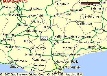
2) Since we also know that the Tun lies on the Lewes-Eastbourne road, then H.'s cottage must lie four miles north of Lewes-Eastbourne road on a north-south line between the Lewes-Eastbourne road and the Lewes Heathfield road. (I discount the possibility that the Heathfield road in question could be the Heathfield-Eastbourne road, since it runs nearly north and south, and a location on it would not be referred to as north of the Lewes-Eastbourne road. Now please examine the first map on the right. Inspection and a little measurement will show that the only possibility for a six mile north-south line between the Lewes-Eastbourne road and the Lewes-Heathfield road must lie between the vicinity of Selmeston and approximately a point on the L-H road west and a little south of Waldron. This would then place H.'s cottage at approximately the bottom of the second "d" in the word Chiddingly.

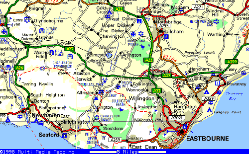
3) Later in TBA when R. is describing her return home from Oxford <[page 288], she states that she lunched along the way at Guildford (Surrey) and stops for tea "on the road to Eastbourne". There are two principle routes one might take from Guildford to Eastbourne, one south and then east through Lewes to Eastbourne on what is now the A27, and the other east and then south from Royal Tunbridge Wells on what is now the A22. These routes meet two miles out of Eastbourne at Polegate, a suburb of Eastbourne. (See the second map on the right)

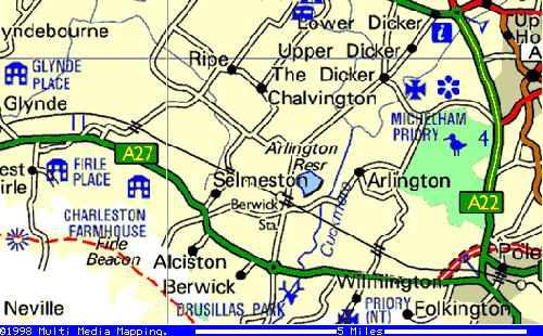
4) Mary later states "Her lights drove on past only when I turned into my own road a few miles from Eastbourne." A look at map number three, which is a blow-up of this junction area shows that there are candidate exit roads on both the A27 and the A22 about two miles from junction which both lead into the Dicker/Arlington/Berwick Station/Selmeston area, in reasonable proximity (walking distance) to the proposed Tun location, and I forward this area as a candidate location for Russell's farm.

I cannot account for the Barker manor house purported location 'three miles from H.'s and with a view of the sea' (unless it's on a damn high hill), or for the location of Tony Sylvester's house 'west of H.'s by the river without access to topological maps which I don't have.
I'm open to contradictions/suggestions/alternatives or
having the whole matter ignored. Regards, JRB
As an addendum, I might note that relatively near (nine miles) to the proposed location of H.'s cottage
is a village called Holmes's Hill.
